Sunday, September 29, 2013

Fall River Bio Reserve Ride


Distance: 26.40 mi
Time: 2:25:03
Moving Time: 1:59:13
Elapsed Time: 2:25:03
Avg Speed: 10.9 mph
Avg Moving Speed: 13.3 mph
Max Speed: 29.9 mph


Brian Pearson and the Fall River Bike Committee hosted this ride around the Bio Reserve, 14,000 acres of protected woodland in Southeastern Massachusetts encompassing Fall River, Westport and Dartmouth, MA.


Fall River Bio Reserve from John Sullivan on Vimeo.

Wednesday, September 25, 2013

Cape Cod Rail Trail


The CCRT starts at the S. Dennis trailhead parking area, conveniently located just minutes from Route 6 on Route 134. Get off at Exit 9A and head south on Route 134 past Patriots Square plaza and Cumberland Farms. About 1/2 mile down from the exit you'll see a sign and parking lot on the left - turn here for the trail entrance.
Distance 50 Miles give or take
Click Here for the Map My Ride Route and stuff. 

I had hear a lot about this trail over the past couple of years. Many friends talk about wanting to ride the MUP but I only got "it's pretty good" from anyone who actually rode it.  There were very few people on the trail this Wednesday afternoon.  Actually there was not much of anything.   As often the case on Rail To Trails, they can be isolated.   That is the case with this trail which boarded by trees for the most part.  The only downtown that is right next to the trail is Brewster and all the others require you to leave the trail and ride a bit on a regular road.  No scenery and no people made for a ho hum ride.

The best I can say is that it's good exercise but really there is very little to see on the trail and I doubt very much if I will ever ride it again.  To add insult to this, I left my bike computer home forcing me to use Map My Ride to get the mileage.  This is one of those trails that is good for the locals and tourists to use as an alternate route by bike.  Even the photos were disappointing on this ride.  I struggled to try to find anything interesting and the best I found was a few sea birds, some Adirondack chairs and an empty general store.    I did get some fitness done today so there was an up side to this ride. 


Saturday, September 21, 2013

2013 Wooney Ride

4th Annual Woony River Ride

Saturday, September 21, 2013

Explore the Woonasquatucket River from Providence to bucolic North Smithfield on our 4th Annual 50/27/10/5 mile bike-a-thon fundraiser for the Woonasquatucket River Watershed Council. The Woony Ride brings out families and avid cyclists from the all over the region to enjoy the beauty of the Woonasquatucket River, a historic asset to the state of Rhode Island. It’s a fully supported ride and it ends with an after-party at Waterplace Park in Downtown Providence - live music, food, and awesome prizes for fundraisers!

46.85 mi
Time: 4:33:45
Moving Time: 3:46:52
Elapsed Time: 4:33:45
Avg Speed: 10.3 mph
Avg Moving Speed: 12.4 mph
Max Speed: 34.8 mph                                                                              


Click Here for the GPS 

Click Here for the photo set


Thursday, September 19, 2013

Ditto


As always, click any photo for big.  Click again for bigger. 
 
 Distance: 22.46 mi

Time: 2:51:28
Moving Time: 2:16:56
Elapsed Time: 2:51:28
Avg Speed: 7.9 mph
Avg Moving Speed: 9.8 mph
Max Speed: 15.7 mph

While riding the Shining Sea Bike trail two days ago, I kept thinking how much wifey would like this ride.  She returned from her trip to Utah last night, had a good nights rest and was more than glad to do this ride.

We drove to Falmouth late morning and began the ride under sunny sky's with very little wind and the temperature in the low 70s.  We took a couple of short side trips off the bike way and rode a little along the waterfront in Falmouth before getting back on the path all the way to Woods Hole.  There we had lunch behind the National Marine Institute in a nice little picnic spot where we could watch the boats navigating Quicks Hole and the ferry that goes to Martha's Vineyard.

Sue enjoying the view

 Bike friendly entrance to a property that sits along side the bike trail.

Bike art along the Shining Sea Bikeway near Woods Hole MA

Tipis at Sippewissett, MA


Tuesday, September 17, 2013

Shining Sea Path. Falmouth to Woods Hole, MA.


 Ferry to Martha's Vineyard at Woods Hole MA.
As always, click any photo for big.  Click again for bigger.
To reach the Shining Sea Bikeway, take Route 24 south to 1-495 south to the Bourne Bridge. From points north, take Route 3 south to the Sagamore Bridge rotary. Follow the signs to Buzzards Bay/Falmouth, then cross over the Bourne Bridge. From Bourne Bridge: travel Rt. 28 south to Falmouth. Exit on Rt 151, bear right. Stay straight on Nathan Ellis Highway which turns into County Rd. at the traffic signal. Continue on County Rd. a few dozen yards. The parking lot is on the right just after passing the Art's Bike Shop and crossing the RR tracks.

 
Distance: 22.58 mi
Time: 2:45:26
Moving Time: 2:08:40
Elapsed Time: 2:45:26
Avg Speed: 8.2 mph
Avg Moving Speed: 10.5 mph
Max Speed: 17.0 mph

Click Here for the Garmin GPS Route.  
Click Here  for the Flickr photos

My bike friend Paul mentioned this ride in his blog last week.  It's one of the Rails to Trails routes I hadn't hear of till then.  After riding this one it went into the "keeper" category.  It's only 11 miles from Falmouth to Woods Hole, MA, but its a really sweet ride.  Flat, with lots of New England ocean scenery and Woods Hole is a wonderful place to hang out while having a light lunch.

Initially I drove well past the head of the trail in Falmouth. Fortunately I met a really nice couple from Connecticut who were about to embark on their bent bikes.  Those are the three wheelers you ride while almost lying down.  They gave me good directions to get back to the trail head which was eight miles back.  We crossed paths again a little later as I rode from the trail head to where we first met.

Crossing paths with the couple on their bents.

I met a few guys who were touring the area.  They are from Upstate NY and were on their way to the Vineyard for a couple of days.  They were having the time of their lives touring on the cheap by camping and cooking their own meals.

A little further down the path something crazy caught my eye. Tipi's.  Three of them off in the woods.
When I saw the name of the campground, Sippewissett an obvious Indian name, tipis made sense.  The other thing was a soda dispenser near the trail.  The campground ran electrical service to run the dispenser and my guess is that they do a pretty good business from those passing by on the trail.

Two of the touring guys from NY. at the Ferry Terminal 

 Lunch spot as Ferry leaves the dock for Woods Hole

Inlet at Woods Hole Ma. 

 Tipi at Sippewissett Camp Ground


Yes, the vending machine is working. 

End of the line. 


Sunday, September 15, 2013

Cape Cod Canal End To End, Both Sides


As always, click any photo for big.  Click again for bigger. Hit your back button to return to the post

There is ample parking at the trail head located adjacent to the Rail Road Bridge.

Click Here for driving directions

Click Here for the GPS of this ride.

Click Here to see all the photos on Google +

Click Here if you prefer Flickr

Distance:24.48 mi
Time:3:16:29
Moving Time:2:31:23
Elapsed Time:3:16:29
Avg Speed:7.5 mph
Avg Moving Speed:9.7 mph
Max Speed:19.2 mph
     It was a last minute decision to ride the Cape Cod Canal. Crossing both the Bourne and Sagamore bridges with a side trip to Mashnee Island made this a 25 mile easy ride on a beautiful day.

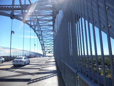
     A short ride from the southern canal entrance brought me to the access for bikers and walkers to cross the Bourne Bridge to the cape side of the canal.  From there it's necessary to back track a bit to get to Mashnee Island and the southern terminus, across the canal from Mass Maritime Academy.  Here is where I came across a very old cemetery that has people who were born in the seventeen hundreds.  One of the lesser known history items of this area is The King Phillip War in the 1690s.  Many familiar names from that war are common around these parts.  Narragansett, Pocaset, and Cataumet are but a few of the common names of that era.

Crossing the Bourne Bridge

Mashnee Island

This was the oldest gravestone with legible markings. 

Massachusetts Maritime Academy at the southern end of the canal looking from Mashnee Island


     After getting back on the canal path it's a wind at your back seven mile ride to the north end of the canal at Sandwich, MA and the power station.


North end of Canal looking from the Cape side.


     The Cape side of the canal path has much less traffic than the mainland side and it's easier to let loose and get some speed up while biking.  The power station is the turn around spot and it's a short ride to the bike access to the Sagamore Bridge via the Christmas Tree Shop parking lot.  Traffic was getting heavy this Sunday afternoon with all the tourists driving off the cape making their way home.  Lots of New York, Connecticut and New Jersey plates today.

Traffic was beginning to build with the tourists leaving the cape via the Sagamore Bridge


     After crossing the Sagamore bridge I again rode to the north end of the canal across from the Sagamore power plant.  There a huge tug and barge entered the canal prompting everyone with a camera, including me, to scurry to the shore line snapping away.  After all that excitement it was time to begin the seven mile return bike ride back to the southern end of the canal.

Tug and barge entering the canal from the Boston side. 


     There were lots of people on this side of the canal both on the path or simply hanging around at the overlooks. Fishermen, bikers, walkers and people who brought a chair and a book simply enjoying the activity on the canal.  Boat traffic on the canal was pretty heavy with mostly pleasure boats.  Every now and then something big would make it's way up the canal and those got everyone's attention.


 Spending time at the canal is  a great way to get outdoors and enjoy a beautiful late summer day. If your around here, try it, I bet you'll love it.  And you could make a new friend like I did.

My new friend.  Click the photo to enlarge for a better look. 


Saturday, September 7, 2013

East Bay Bike Path. Providence, R.I.


As always, click any photo for big. Click again for bigger.

To see Garmin route   CLICK HERE

Distance:19.22 mi
Time:1:42:09
Moving Time:1:33:56
Elapsed Time:1:42:09
Avg Speed:11.3 mph
Avg Moving Speed:12.3 mph
Max Speed:23.9 mph

It was difficult to get out of bed this morning after the fiasco of last nights US loss to Costa Rica in the World Cup Qualifying match.  That 3-1 drubbing will only make the game in Columbus against Mexico in a couple of days all the more exciting.  To make it even more exciting, I have a ticket, a plane ride and a hotel.  

We all met at the parking lot in Warren R.I.  and rode to Providence and back.  I didn't continue on to Bristol and don't know if anyone else did, because I did a fitness ride today hammering my way back to the car and was quite a bit ahead of the rest.  

Here is the rest of the story in pictures.